What is the FORSCE project?
The project aims to develop a world unique operational fleet of coastal and environmental science research (FORSCE) to conduct studies on coastal areas, during any season.
With more than 16% of the world coastlines, Canada ranks first among countries with access to the sea. Coastal zones are of paramount importance for economic and social development on a global scale. It is also at the edge of coastal areas that ecosystems are most productive, providing vital ecological services to populations. These regions are experiencing the greatest environmental changes, mainly due to human disturbance (destruction of 20% of coral reefs, loss of 20% of coastal marshes, decline in fish stocks, increase of hypoxic or dead zones, etc.), but also due to the acceleration of global sea-level rise, one of the most consequential effects of global warming.
In colder regions, reduced ice cover will increase the coastal zone’s exposure to extreme events such as winter storms, as well as accelerate cliff retreat and permafrost melt. As a result, there is an increase in the exchange of mineral and organic matter, the effects of which on coastal ecosystems, food webs and biogeochemical cycles are virtually unknown. Accelerated sediment transport also causes problems in port areas and waterways. Yet paradoxically, the shallow coastal zone, which varies from a few meters to a few kilometers wide depending on the region, is also the least documented due to the lack of suitable study platforms. Knowledge on winter processes is particularly limited, making it difficult to assess the impacts of warming in marginal areas of ice and coastal ice until now. There is an urgent need to develop new platforms adapted to winter and ice conditions in order to properly assess these environmental upheavals and find effective adaptation solutions, while supporting the maritime industry.
With the collaboration of researchers at the national and international level and several federal, provincial, private and not-for-profit organizations, we aim to take a fresh look on coastal zones by creating synergy between different coastal science disciplines and on a collaborative approach between several sectors of the maritime environment (transport, risk management, fisheries, heritage, ecotourism, etc.) and organizations.
The operational fleet consists of:
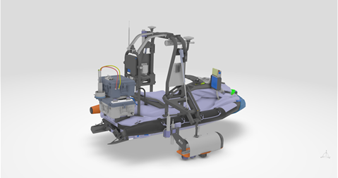
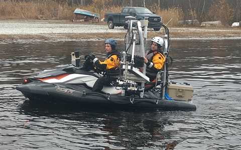
- a watercraft suitable for navigation in icy and shallow waters,
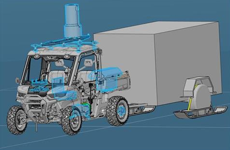
- a tracked vehicle that can travel on landfast and pack ice,
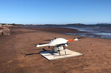
- an unmanned aerial vehicle (UAV) equipped with LiDAR,
- a multispectral camera and an oblique photo camera system,
- two mobile laboratories,
- a geospatial technology laboratory, and,
- a Web platform for sharing data and exchanging information on maritime issues.
Infrastructure and instruments
As a part of FORSCE, two types of motorized vehicles adapted to winter conditions will be developed in close collaboration with the Advanced Technology Center of Bombardier Recreative Products (CTA-BRP): multi-instrument watercrafts and multi-purpose tracked vehicles (Yeti) towing laboratories and capable of travelling over uneven surfaces such as coastal ice.
- Watercraft: this navigation platform includes a variety of measuring instruments, GPS antennas, an inertial platform, a LiDAR laser scanner, single-factor and multibeam echo sounders, a sediment profiler, a video camera, multiparameter probes and spectroradiometers. These equipments will gather a wide range of information such as high-resolution and accurate bathymetric data, bottom stratigraphy, substrate and habitat types (vegetation), physico-chemical (temperature, conductivity, oxygen, pH, CO2) and bio-optical (spectral reflectance, chlorophyll-a, particulate and dissolved carbon) properties of the water column;


- Yeti: this all-terrain vehicle equipped with a heated cockpit includes a LiDAR, a multispectral camera, an inertial navigation system, a computer and is is designed to tow a mobile laboratory equipped with computer stations to carry out spatial analysis and image processing directly at the study sites. It will also e equipped with a remotely operated underwater vehicle to describe substrate and habitat types and the water-ice interface;

- A unmanned aerial vehicle (UAV) integrating a multispectral camera, two high-resolution colour cameras, a LiDAR, an inertial and georeferencing platform that can be deployed in all coastal environments from land or an oceanographic vessel;

- A biogeochemical measurement and analysis laboratory for rapid in situ processing of ice, sediment, water, biological material and gas samples;
-
A research laboratory in geospatial technology applied to coastal and environmental sciences based in the Geomatics Department at Cégep de l'Outaouais; and,
- An innovative platform for analysis, exchange and WEB dissemination: the virtual platform will enable the dissemination of knowledge and the exchange of information on coastal zone issues with partners from different sectors, users and citizens.
Associates and partners
FORSCE brings together experts from several fields of research (physical oceanography, geomatics and remote sensing) and several universities (UQAM, U. Laval, McGill, Calgary, Memorial, Arizona State (USA); Brest (France); Potsdam (Germany)), colleges (CEGEP Outaouais), federal (Fisheries and Oceans Canada; Canadian Hydrographic Service; Canadian Coast Guard; Geological Survey of Canada) and provincial ministers (Sécurité publique, Transports Québec, Environnement et Lutte contre les changements climatiques), private companies (CartoVista, Bombardier Recreative Products, instruments suppliers), and not-for-profit organizations working in technology transfer and R&D (Research and Development Center in Coastal and Ocean Mapping – CIDCO, ZIP committees).
Main researchers-users:
Pascal Bernatchez, UQAR
Philippe Archambault, U. Laval
Simon Bélanger, UQAR
Gwénaëlle Chaillou, ISMER-UQAR
Anne de Vernal, UQAM
Dany Dumont, ISMER-UQAR
Patrick Lajeunesse, U. Laval
Christian Larouche, U. Laval
Christian Nozais, UQAR
Guillaume St-Onge, ISMER-UQAR
Other users:
Christophe Delacourt (IUEM), Thomas Buffin-Bélanger (UQAR), Brent Else (University of Calgary), Rodolphe Devillers (Mémorial University of Newfoundland), Hugues Lantuit (University of Postdam), Gavin Manson (Geological Survey of Canada-Atlantic), Ian Walker (Arizona State University), Alfonso Mucci (McGill University), Marcel Babin (U. Laval), Nicolas Seube (CIDCO), Emmanuel Devred (MPO), Yann Ropars (Consultant Ropars inc.), Louis Maltais (MPO), Laurent Chauvaud (UBO), Jean Stöckli (Cégep de l'Outaouais), Mathieu Cusson (UQAC), Chris McKindsey (MPO), Michel Starr (MPO), Dany Bouchard (CartoVista Inc.), Cesar Fuentes-Yaco (MPO)
Financial partners:

